


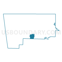
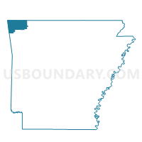
Voting District 046, Benton County, Arkansas
About
Outline

Summary
| Unique Area Identifier | 525920 |
| Name | Voting District 046 |
| County | Benton County |
| State | Arkansas |
| Area (square miles) | 11.40 |
| Land Area (square miles) | 11.34 |
| Water Area (square miles) | 0.06 |
| % of Land Area | 99.43 |
| % of Water Area | 0.57 |
| Latitude of the Internal Point | 36.23493230 |
| Longtitude of the Internal Point | -94.19567330 |
Maps

Graphs
Select a template below for downloading or customizing gragh for Voting District 046, Benton County, Arkansas


Neighbors
Neighoring Voting District (by Name) Neighboring Voting District on the Map
- Voting District 018, Benton County, AR
- Voting District 042, Benton County, AR
- Voting District 044, Benton County, AR
- Voting District 045, Benton County, AR
- Voting District 047, Benton County, AR
- Voting District 048, Benton County, AR
- ELM SPRINGS Voting District, Washington County, AR
- SPRINGDALE PCT 7, Washington County, AR
Top 10 Neighboring County Subdivision (by Population) Neighboring County Subdivision on the Map
- Springdale township, Washington County, AR (66,328)
- Township 4, Benton County, AR (25,596)
- Township 13, Benton County, AR (13,230)
- Elm Springs township, Washington County, AR (2,126)
Top 10 Neighboring Place (by Population) Neighboring Place on the Map
- Springdale city, AR (69,797)
- Rogers city, AR (55,964)
- Lowell city, AR (7,327)
- Cave Springs city, AR (1,729)
- Elm Springs city, AR (1,535)
Top 10 Neighboring Unified School District (by Population) Neighboring Unified School District on the Map
- Springdale School District, AR (90,624)
- Rogers Public Schools, AR (81,256)
- Bentonville Public Schools, AR (74,655)
Top 10 Neighboring State Legislative District Lower Chamber (by Population) Neighboring State Legislative District Lower Chamber on the Map
- State House District 94, AR (48,316)
- State House District 99, AR (47,695)
- State House District 100, AR (36,953)
- State House District 97, AR (34,766)
Top 10 Neighboring State Legislative District Upper Chamber (by Population) Neighboring State Legislative District Upper Chamber on the Map
- State Senate District 9, AR (116,144)
- State Senate District 8, AR (105,195)
- State Senate District 35, AR (102,238)
Top 10 Neighboring 111th Congressional District (by Population) Neighboring 111th Congressional District on the Map
Top 10 Neighboring Census Tract (by Population) Neighboring Census Tract on the Map
- Census Tract 213.10, Benton County, AR (7,382)
- Census Tract 105.09, Washington County, AR (6,795)
- Census Tract 105.01, Washington County, AR (4,769)
- Census Tract 213.11, Benton County, AR (4,395)